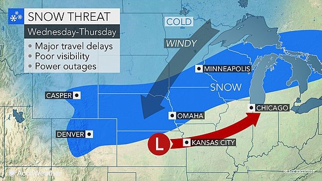
AccuWeather Global Weather Center – March 22, 2016 – AccuWeather reports a storm will deliver heavy snow from Colorado to Michigan, with the potential for blizzard conditions in part of the north-central United States, during Wednesday and Thursday.
The storm will hit hard and fast from the eastern slopes of the Rockies to the Great Lakes region. The storm will bring major disruptions to travel, school and other daily activities, prior to the Easter holiday.
The storm will impact thousands of miles of roadways. Major highways in the north-central United States that are likely to be affected by snow and/or wind include Interstate 25, I-35, I-39, I-43, I-70, I-75, I-80, I-90 and I-94. Travel along these highways will become hazardous.
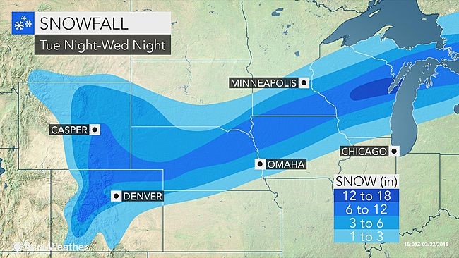
A large swath of 6- to 12-inch snow will occur with the storm from northeastern Colorado and southeastern Wyoming to northern Michigan.
Motorists could get caught in the fast-hitting storm. Some highways could close for a time.
Plowing crews may struggle to keep up with snowfall rates of 1-2 inches per hour, in some cases, especially if highways become clogged with stalled vehicles.
“While some of the snow will melt as it falls on paved areas during the daytime, where it snows hard, roads will become slushy and then snow-covered,” according to AccuWeather Meteorologist Steve Travis.
Airline passengers should be prepared for delays, especially those with connecting flights to and from secondary airports in the swath of heavy snow. It is possible that some crews and aircraft may be displaced due to the magnitude of the storm.
This map shows anticipated snowfall through Wednesday night on non-paved surfaces. Additional snow will fall over the Upper Midwest on Thursday.
Cities that are likely to receive accumulating snow from the storm include Denver; Cheyenne, Wyoming; Grand Island, Nebraska; Sioux Falls, South Dakota; Mason City, Iowa; Minneapolis and Rochester, Minnesota; Green Bay, Wisconsin; and Alpena, Michigan.
“Portions of the Plains will go from delightful spring warmth to windswept snow and cold in less than 24 hours during the middle days of this week,” according to AccuWeather Chief Meteorologist Elliot Abrams.
For example, in Omaha, Nebraska, after temperatures hover in the lower 70s during Tuesday evening, heavy rain and wet snow are in store with temperatures near 32 during Wednesday evening.
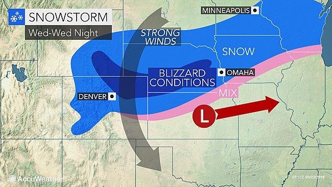
“As the storm strengthens, strong winds will develop and lead to blizzard conditions over the central High Plains with extensive blowing and drifting snow,” Travis said. “Blizzard conditions will first develop over portions of Colorado, Wyoming and Nebraska on Wednesday.”
More of a wet snow with slightly less wind will occur farther to the east in portions of Wisconsin and northern Michigan. However, portions of the Great Lakes region may receive the biggest snowfall from the storm with 12-18 inches of snow possible. The snow will be much more dense than lake effect and may be difficult to shovel and plow.
Severe thunderstorms and heavy rain will develop in the storm’s warm sector, while snow falls in the colder air.
Even where little or no snow accumulates, rain, thunderstorms and gusty winds can cause airline delays.
Substantial airline delays are possible in Kansas City, Missouri, Chicago, Detroit, St. Louis and Cincinnati.
Gusts in part of the snow area, as well as ahead of the storm and immediately in its wake, will range between 35 and 50 mph. The winds will be strong enough to cause sporadic power outages and create difficulties for drivers of high-profile vehicles.
The next stop for the snowstorm and wintry mix will be portions of central and southern Ontario and Quebec, and perhaps northern New York state and New England, late in the week.


