AccuWeather Global Weather Center – March 29, 2016 – AccuWeather reports a blast of arctic air, combined with gusty winds, will take aim on the Upper Midwest and Northeast this weekend.
The polar vortex will briefly drop over the Hudson Bay in Canada. From this position, arctic air will have a direct route into the northern tier of the eastern United States.
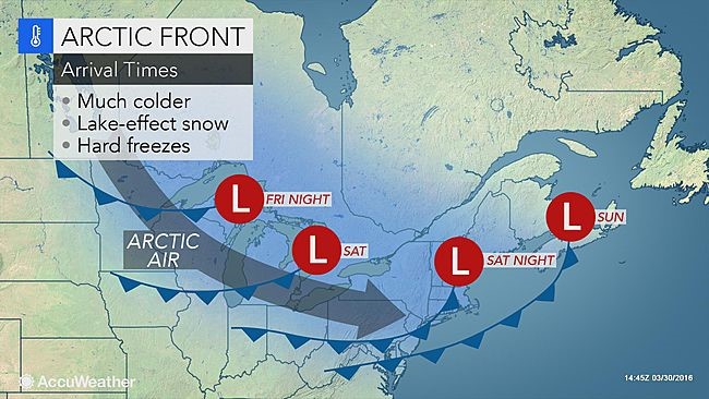
The main thrust of the cold air will arrive across the upper Great Lakes on Saturday and will settle into New England, New York, Pennsylvania and New Jersey on Sunday.
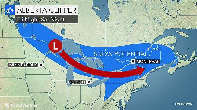
This graphic shows the track of an Alberta Clipper storm and the timing of the leading edge of the arctic air. Temperatures will climb ahead of the arctic push.
“Temperatures in the swath of the arctic air will be 10-20 degrees Fahrenheit below normal, which will be the largest negative anomalies since Valentine’s Day,” AccuWeather Long-Range Meteorologist Joe Lundberg said. “When the wind is factored in, it will feel a whopping 40-60 degrees colder than it will late this week.”
This weekend, normal highs are in the lower to middle 50s in Minneapolis, Chicago, Detroit, Cleveland and Boston, the upper 50s in Pittsburgh and New York City and the 60s in Philadelphia.
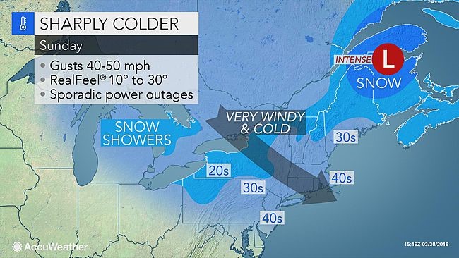
During the peak of the cold air, daytime temperatures will be no higher than the 20s from northern Minnesota to northern Michigan, northern upstate New York and northern New England. Temperatures at night will dip into the lower teens and single digits over much of this swath.
Winds will gust between 40 and 50 mph over much of the swath as the arctic air approaches and settles in. Gusts topping 50 mph are possible from eastern Pennsylvania and New Jersey to New England.
Airline delays and difficulties for high-profile vehicles are likely. The gusts could be strong enough to cause sporadic power outages.
The combination of wind, cold, dry air and other factors will result in AccuWeather RealFeel® Temperatures 10-20 degrees lower than the actual temperature.
Buds and blossoms that have pushed out on some fruit trees, bushes and vines could be damaged.
The air will become plenty cold enough to trigger bands of lake-effect snow and snow showers. Some of the snow showers can extend all the way to the coastal areas of the Northeast.
In addition, an Alberta Clipper storm will produce a swath of steady snow from parts of northern Minnesota to portions of northern and western Pennsylvania, upstate New York and New England this weekend.
Enough snow could fall to cover the ground and make for slippery spots on area roads.
It is behind this clipper that gates of the arctic will be opened, and it may take until Monday until the lowest temperatures of the outbreak are realized.
“The worst blast of cold air will be the first episode this weekend into Monday,” according to AccuWeather Lead Long-Range Meteorologist Paul Pastelok.
One and possibly two additional thrusts of arctic air will follow next week.
A second clipper storm could spread steady snow a bit farther to the south from Monday into Tuesday. Correspondingly, some chilly air could push farther south than from the first blast in the wake of the second clipper.
“The second and third pushes of cold air will pale in comparison to the weekend arctic outbreak,” Pastelok said. “The two additional cold waves will not have nearly as much wind with them and the source region of the cold air will trend less extreme as the polar vortex begins to retreat northward.”
While temperatures could approach the level of cold experienced with the blast this weekend, RealFeel Temperatures may be significantly higher with the additional cold waves next week.
Beyond next week, the arctic air will be turned off. However, episodes of clouds, rain from the Gulf of Mexico and the Pacific Ocean, and easterly winds from the Atlantic will play roles in holding back temperatures.


